Showing posts with label Camping. Show all posts

Wednesday, 20 August 2025

Yosemite - Granite Grandeur

Yosemite National Park is an icon of California. It is visited by more than 4 million visitors every year. Ghumakkad visited Yosemite on 17-18 Aug 2025 along with three other nature lovers.

The Travellers

Who were the four travellers to Yosemite?Other than Ghumakkad, all three live in the Bay Area in California. Special thanks to each one of them for making this trip happen.

Ankur- An IT pro with 12 patents to his credit. My son-in-law, a golfer, dancer who loves life and all things tech.

Akanksha (Ashi)- An interior designer, photographer, poet, my daughter and a compassionate volunteer and parent.

Satyam- An IT pro, quiet by nature, mathematics enthusiast, keen traveller and hiker.

Harsh-the-Ghumakkad- whom you all know- a Navy Veteran, golfer, blogger, teacher, hiker and Nature lover. This was my visit to USA after a gap of 11 years. 


About Yosemite

Yosemite National Park is managed by the National Park Service and covers an area of 3000 sq kms. However, most visitors spend the majority of their time in the valley's 18 sq km area. Designated a World Heritage Site in 1984, Yosemite is internationally recognized for its granite cliffs, waterfalls, clear streams, groves of giant sequoia trees, lakes, mountains, meadows, glaciers, and biological diversity. Yosemite was critical to the development of the concept of national parks. President Abraham Lincoln signed the Yosemite Grant of 1864 that declared Yosemite as federally preserved land. According to Wikipedia, the word Yosemite (derived from yohhe'meti, "they are killers" in Miwok) historically referred to the name that the Miwok gave to the Ahwahneechee, the resident indigenous tribe. The term Yosemite in Miwok is easily confused with a similar term for "grizzly bear", and is still a common misconception. For detailed history of Yosemite, the readers may refer Wikipedia. It is interesting to note that tourism significantly increased after the first transcontinental railroad was completed in 1869, while the long horseback ride to reach the area was a deterrent.

The park contains thousands of lakes and ponds, 2600 km of streams, 1,300 km of hiking trails, and 560 km of roads.


From Ankur's residence in Pleasanton, the Park is 230 miles east. It is about four hrs drive including 6 of his EV. See the map below:


Notable Spots

Tunnel View - a scenic viewpoint located on California State Route 41 in the Park. Since its opening in 1933, it has offered visitors iconic, expansive views of Yosemite Valley, making it one of the park's most renowned viewpoints.


El Capitan, a 3000 feet granite monolith on Yosemite Valley's northern escarpment


Close to El Capitan are 'Three Brothers' rocks.

Half Dome - It is a quartz monzonite batholith at the eastern end named for its distinct shape. One side is a sheer face while the other three sides are smooth and round, making it appear like a dome cut in half.

North Dome - is a granite dome in the southernmost summit of Indian Ridge, one km north of Washington Column and the Royal Arches on the northeastern wall of Yosemite Valley.

Royal Arches - An inset arch on giant rock face.

Washington Column - a roughly 1800-foot high rock formation, arising from Yosemite Valley. It can be viewed from many points in Yosemite Valley including the trail to Mirror Lake.

Yosemite Falls - the highest waterfall in the Park, dropping a total of 2,425 feet from the top of the upper fall to the base of the lower fall. When we visited on 17th August,  the waterfall had completely dried up. 


Even the lower falls had dried up completely.


Mirror Lake - The iconic mirror lake had shrunk to a tiny pond. It was very disappointing for Ankur, Ashi and Satyam because they had all frolicked and jumped from a rock into waist deep water last season. Pictures of our hike to the dried up Mirror Lake below.


All that the dried up Mirror Lake offered was some waves caused by strong winds. See the video below.


But the Merced river compensated with some stunning views next morning, reflecting sunlit granite peaks in the water.


You can feel the river and its ripples in the video below.


Sequoia Tree Groves - The park has three groves of ancient giant sequoia (Sequoiadendron giganteum) trees; the Mariposa Grove (200 trees), the Tuolumne Grove (25 trees), and the Merced Grove (20 trees). This species grows larger in volume than any other and is one of the tallest and longest-lived. 


We stayed overnight to enjoy the beauty of dusk, dawn and a short hike in Yosemite. There are numerous trails for hiking for all age groups. Sharing below few pictures of our hikes.


Star Gazing

Yosemite offers unique opportunity for star gazers. With clear skies and complete darkness, we could see thousands of stars and milky way. Sharing two pictures shot by Ashi.


Here is a video to give you a feel of the night experience in Yosemite.

Yosemite Tour

You can see the Park by riding a free shuttle bus. There are three routes coloured differently. Just hop on and off. In addition,  there is a paid ride in an open coach with a ranger guide with excellent commentary. Mark our guide has volunteered and later worked at the Park for the last 60 years.


Bear Traps

The Park has some 500 Black Bears. They love to eat the food left in the tents. With a strong sense of smell,  they forage for food and any other scented items in visitors' bags at night. Therefore,  in the tented accommodation where we had stayed, we had to lock up all scented items like toothpaste,  Vaseline and food in a metal safe kept outside the tent. Picture below.


In addition,  there are Bear Traps placed near the camps.


Hope you enjoyed the Yosemite Park armchair tour with us. You have to visit the Park to feel its vastness and ecological diversity. Signing off with another picture with a fallen tree trunk.


Thanks for browsing and stay connected. 

   - Harsh-the-Ghumakkad with Akanksha Bhargava/ Yosemite National Park/ 19th Aug 2025

#yosemite #NationalParkService #California #hiking #ghumakkadhb #ghumakkadharsh


Sunday, 18 October 2020

Wooden Electric Pole KBG-43 Answer

'It is a backpack holder'

'Mast of a sailing vessel'

'Flag pole of the large National flag'

'Tubular high mast for solar lights or for perimeter lighting of Airport'

'Telephone pole'

'Steel based high circular wooden masts for flood lights or solar lights', these were some of the responses received for KBG-43, the 43rd edition of online travel quiz Kaun Banega Ghumakkad.

Wooden electricity pole was the correct answer.

Wooden poles continue to be used in many countries for electricity transmission. The picture was taken by Ghumakkad in the Bay Area of California, USA. While on a hike in a Forest Reserve, I noticed these wooden poles which were treated for pests, neatly polished and numbered. 

While returning from the camping site, we observed that similar poles were in use around the cities and towns also. 


The high tension transmission towers though were metallic structures as in other countries. See the picture below from northern fringe of SF Bay, California.

The toe holds on the poles were given as a clue in the contest. These holds are necessary for climbing the poles for any maintenance or repair. Since the poles were located in a hiking area, to prevent any accidental or adventurous attempt to climb by unauthorised personnel, bottom few sets of hand holds are detachable. Very thoughtful design. Otherwise in other countries, the bottom rung of the poles or towers are wrapped in barbed wires to prevent accidental/unauthorised climbing.

Since tall trees like the conifers, redwood and fir grow abundantly in California, wooden poles continue to be used for electricity transmission.

Winners

KBG-43 generated good response with almost 300 participants. However, only two readers gave the correct answer. Another anonymous response, though correct, goes unrewarded. Congratulations to both the winners who are profiled below:

  1. NR Ravi: Former Captain Indian Navy who after retirement worked as the Chief Designer in an electronics manufacturing company and later as a Professor in a leading engineering college in Chennai. Loves travelling and gardening.
  2. Ranajit Sen: A Pharmacy graduate from BITS Pilani. After more than 40 years in pharma industry, Ranajit is now an advisor to the Govt of India and leading bio-tech companies.

Thank you for your continued support to KBG Kaun Banega Ghumakkad contest.
We hope we have helped you in taking your mind off Covid and Corona.

Stay safe. More KBGs will follow.

    -  Harsh-the-Ghumakkad with Neeta Bhargava/18th Oct 2020

#travelchallenge #hiking #virtualtravel #ghumakkadhb #ghumakkadharsh #KBG #kaunbanegaghumakkad #onlinecontest #powerofobservation #lockdownfunathome #beatthecorona #lockdown #stayhomestaysafe  #funwithtravel #learningfromtravelling #woodenelectricpole #ecofriendlymaterials

Tuesday, 31 July 2018

Coyote Gulch- Hiking in a Stream

We all hike in the mountains.
In forests.
In river valleys.
In the desert and so on.
Have you ever hiked in a flowing stream in a canyon?
And camped for two nights?

Ghumakkad's ten-year old grandson did that. Of course with his parents and friends. But it is creditable for the two families to go on a hike in water. Complete with hiking poles, loaded back pack and their three-year old  toddler too! This is a guest story written by Nikhil, my grandson. Pictures courtesy Ankur Bhargava and Abha Maheshwari. Used with permission. 

What is Coyote Gulch? Coyote Gulch is a slot canyon in the middle of Utah’s massive red rock country. See the two maps below.


There are numerous blogs about the trail which give further details.
Here is Nikhil, the author who wrote this story when he was ten years old!

Nikhil's story follows:
_____________________________________________________ 


Hike name – Coyote Gulch in the Grand Staircase Escalante Area, Utah, USA

Duration - 3 days and 2 nights

Team – Abha, Soumitra, Ankur, Akanksha, Nikhil (10), Arushi (9), Rohan (7), Naman (3)


Day 1

Drove on a dirt road named BLM255 for about 2 hours to reach the trail head.

Our trail was called the Hurricane Wash via Chimney Rock. This way we would cut down our hiking time by half, not knowing what lay ahead for us.


We reached chimney rock in time, - 11:30 - but we lost all the time that we made, to find our way to Hurricane Wash. We wasted about a mile in navigating our way to the wash over the rocky terrain. I was carrying about 17 pounds, dad was carrying about 27 pounds, and mom was carrying Naman.

We had lunch on a tall rock since everyone was exhausted and then started walking again to find the entrance into the trail. We finally found the drop to the trail around 2:30 pm. The trail was very sandy and made it more difficult to walk even though it was all flat. Gradually the ground started getting wet and gave way to visible water which led to the river.

We changed from our hiking shoes into our water shoes and neoprene socks – special socks that do get wet in the water but keep you warm once you are out of the water.


We followed the river for the next 2-3 miles to Jacob Hamblin Arch which was our destination to camp.

It was a sight to behold. One because it was so impressive and huge and secondly because we were all tired and couldn’t walk anymore :-). We all got to our respective jobs – pitching tents, filtering water, preparing to cook dinner and playing (kids).

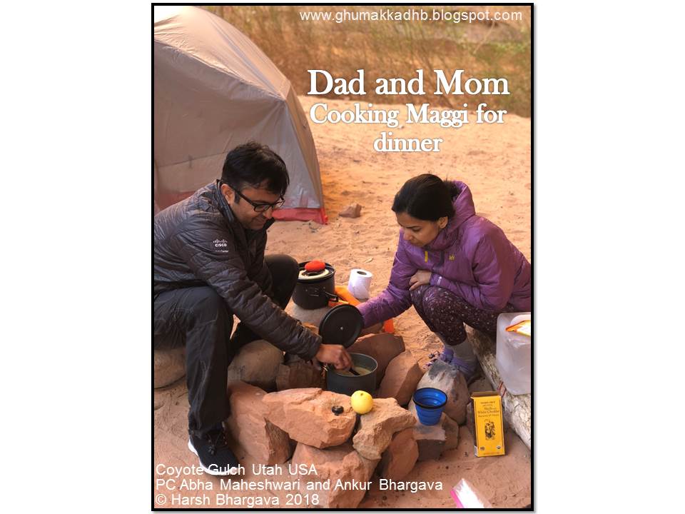
We had Maggie for dinner and mom made mac and cheese for the picky eater Naman.


We all went to bed instantly after dinner since fires are not allowed in the park. Once inside the tent, I was bored, because I was not so sleepy. Mom and I did some stretching because my legs were hurting. That relaxed my muscles and I fell asleep. It was really warm that night. But the wind was howling – hoo whooo . It woke me up four times.

Day 2

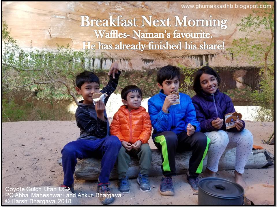
We woke up. Enjoyed some packaged mini waffles and ate oats for breakfast.


Mom – dad and Soumitra chachu (Dad's brother in Hindi)– Abha mausi (Mom's sister in Hindi), took some pictures against the arch while we kids were busy making a castle.


We then all changed into our water gear and headed out for the day. We hiked for about 4 miles and saw two water falls, the Coyote Natural Bridge and a little gateway.


Took some pictures along the way and our precious cargo – Naman – changed shoulders couple times..


At about 4pm it was time to head back to our campsite. It had started to get cold. It was a windy day, compared to the previous day. I was leader for most part of the hike and had to set a pace.


Parents made Chole and Rice for dinner. We had to hide our bowls under our jackets because the wind was so strong that it was blowing sand all over. There was sand everywhere – on the ground, in our eyes, in our mouth, inside the tents, and in food.

We kids, were in one tent, while the grown ups and Naman were in another. We slept and called it a day. It was windier than the previous night.

Day 3

There was this one time when Abha mausi and Soumitra chachu got a little separated and I and my parents and Rohan and Arushi were all together. We kept hiking thinking that A and S are right around the corner. We hiked on the trail to keep away from the water and then again stepped into the water when there was no trail/land.


It was at one such instance that we lost our way. Mom and Dad turned around and said, “We should wait for A and S. Its been a while since we saw them” – not knowing that we were the ones who were actually lost!!! Dad said “ let me look at the map, if we are on the right track “ And guess what??? WE WERE OFF THE TRAIL. We kind of panicked a bit, because we had thought that they were the ones lost, so it would be pretty hard to retrace our steps. We had decided on a distress call code “ huku huku “ and would keep repeating it until the rest of the party replies to it. Luckily, Soumitra chachu heard us and ran to where we were - shouting “Ankur.” We followed Soumitra chachu to where we were supposed to go and got back on the trail.


We hiked through a different path once we found the rocky terrain, which had new obstacles we didn’t know about. Once within view of Chimney Rock, Naman got down from his carrier and started to scale the steep rock walls, making everyone ashamed of themselves. See the video clip below.


Naman was climbing the rocks like a spider.

We got off the path by a lot, but found our way back to Chimney Rock. Everyone was so happy when we reached the car. We (as in the whole party) hadn’t eaten anything besides an energy bar, so everyone opened all packages and started hogging.

_________________________________________________________________________

That was the end of Nikhil's story. Amazing, isn't it?

Nikhil and I had hiked together earlier. The story of one such hike in India can be browsed by clicking "Father's Day Hike".


Another outing where Nikhil and Ansh our eldest grandson in India, co-authored a story was 'Why Kodaikanal'. We can see two of them together in the picture below.


So, this story was special. Not because it featured an off-beat trail in USA, but because it had been written by a ten-year old hiker himself. Thanks Nikhil. And thanks Abha and Ankur for incredible pictures and the videos. May you all keep hiking!

Thanks for browsing

   -  Harsh-the-Ghumakkad with Nikhil Bhargava/ 31st July 2018

#coyotegulch #Hamblinarch #hiking #canyon #chimneyrock #naturalbridge #camping #ghumakkadharsh #ghumakkadhb #hurricanewash